


Firoz Shah Kotla
Jahanpanah
Tughlaqabad Fort
Firoz Shah Kotla
The Feroz Shah Kotla was originally a fortress built by Sultan Ferozshah Tughlaq to house his version of Delhi city called Ferozabad. A pristine polished sandstone pillar from the 3rd century B.C. rises from the palace's crumbling remains, one of many pillars left by the Mauryan emperor Ashoka; it was moved from Punjab and re-erected in its current location in 1356.Ever wondered about the historical background of the Ferozshah Kotla ground on Delhi's Bahadur Shah Zafar Marg? The name, as we all know, has been derived from the Emperor of Delhi, Feroz Shah Tughlaq, who ruled from 1351 to 1388.
But not many know that he had a passion for building and during his lifetime, he went in for construction of mosques and palaces in such a big way that his name has been imbibed in history books as a builder. He also built hunting lodges, reservoirs for irrigation and embankments. He was the ruler during whose reign the medieval bastion along the banks of river Yamuna was built.
During the days of the British Raj, the Englishmen wanted to play cricket on the outskirts and they built Willingdon Pavilion. According to Sunil Khanna, Joint Secretary, Sports, Delhi District Cricket Association, "The name of the ground Feroz Shah has been derived from the emperor's name".
Jahanpanah
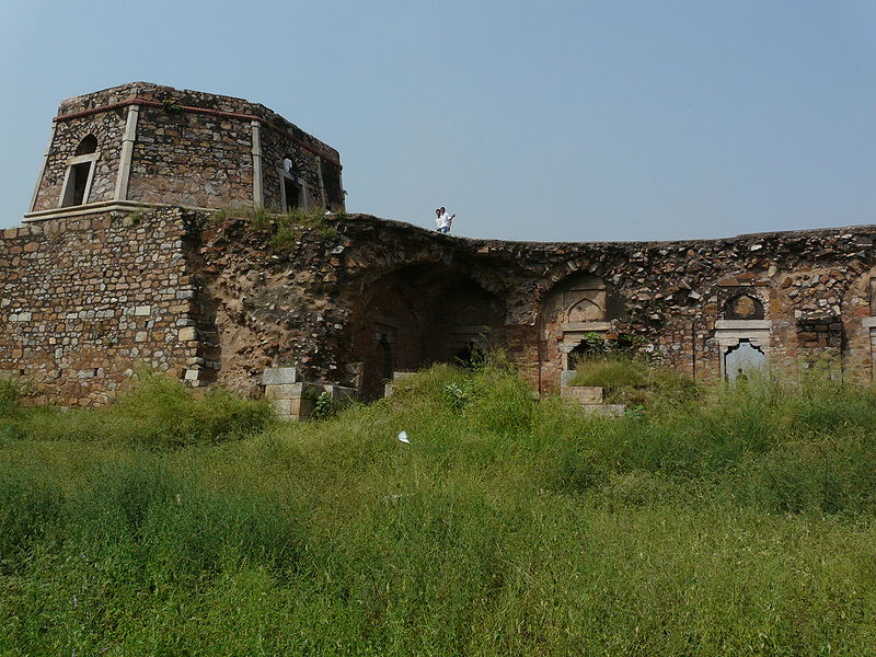
Jahanpanah was the fourth medieval city of Delhi established in 1326-1327 A.D. by Muhammad bin Tughlaq (1321-1351), of the Delhi Sultanate. To address the constant threat of the Mongols, Tughlaq built the fortified city of Jahanpanah (meaning: "Refuge of the World") subsuming the Adilabad fort that had been built in the fourteenth century and also all the establishments lying between Qila Rai Pithora andSiri Fort. Neither the city nor the fort has survived. Many reasons have been offered for such a situation. One of which is stated as the idiosyncratic rule of Mohammed bin Tughlaq when inexplicably he shifted the capital to Daulatabad in the Deccan and came back to Delhi soon after.
The ruins of the city’s walls are even now discerned in the road between Siri to Qutub Minar and also in isolated patches behind the Indian Institute of Technology (IIT), in Begumpur, Khirki Masjid near Khirki village, Satpula and many other near by locations; at some sections, as seen at Satpula, the fort walls were large enough to have few in built store rooms to stack provisions and armory. The mystery of the city’s precincts (complex) has unfolded over the years with later day excavations revealing a large number of monuments in the villages and colonies of South Delhi. Due to compulsions of urban expansion of the Capital City of Delhi, Jahanpanah is now part of the upscale urban development of South Delhi. The village and the wealth of ruins scattered all around are now enclosed by South Delhi suburbs of Panchshil Park South, Malviya Nagar, Adchini, the Aurobindo Ashram, Delhi branch and other smaller housing colony developments. It is hemmed in the North–South direction between the Outer Ring Road and the Qutb Complex and on the east–west direction by the Mehrauli road and the Chirag Delhi road, with Indian Institute of Technology located on the other side of the Mehrauli road as an important landmark.
Begampur Mosque
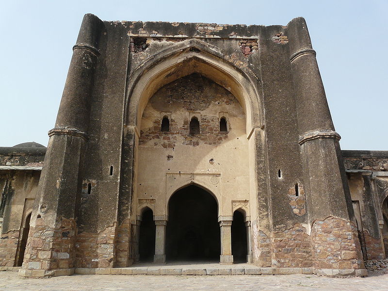
The Begumpur Mosque, a vestige of the old city, of overall layout plan of 90 m (295.3 ft)x94 m (308.4 ft) size with the inner courtyard measuring 75 m x 80 m, is said to be patterned on an Iranian design planned by the Iranian architect Zahir al-Din al-Jayush. A majestic building in the heart of the city with a pride of place played a pivotal role of serving as a madrasa, an administrative centre with the treasury and a mosque of large proportions serving as a social community hub surrounded by a market area. It has an unusual layout with three arch covered passages
Construction of this mosque is credited to two sources. One view is that it was built by Khan-i-Jahan Maqbul Tilangani, Prime Minister during Feroz Shah Tughlaq’s rule, who was also builder of six more masjids. The other view is that it was built by Tughlaq because of its proximity to Bijay Mandal and could probably be dated to 1351 A.D., the year Tughlaq died here. In support of the second view, it is said that Ibn Batuta, the chronicler of the period had not recorded this monument. The Mosque considered an architectural masterpiece has three gates, one in each of the three covered passages, in North, East (main gate) and South directions. The entire passageway of the west wall has twenty five arched openings. The eastern gate approach is from the road level up a flight of steps to negotiate the raised plinth on which this unique mosque has been built with a four Iwan layout. Stone chajjas or eaves can also be seen on all the four arcades. The Northern entry with 1 m raised entrance, probably linked the Mosque to the Bijayamandal Palace. The mosque was under occupation during Jahanpanah’s existence till the seventeenth century. In the later period, encroachers had occupied the mosque but were cleared by the ASI in 1921. A shuttered by lane entry from the north has been interpreted as an approach that was used by the womenfolk of the Sultan’s family for attending prayers in the mosque.
Tughlaqabad Fort
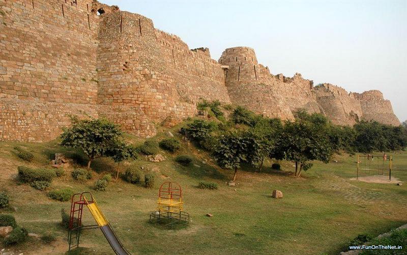
Tughlaqabad Fort is a ruined fort in Delhi, stretching across 6.5 km, built by Ghiyas-ud-din Tughlaq, the founder of Tughlaq dynasty, of the Delhi Sultanate of India in 1321, which was later abandoned in 1327. Ghazi Malik aka Ghias-ud-din Tughlaq was a feudatory of the Khilji rulers of Delhi, India. Once while on a walk with his Khilji master, Ghazi Malik suggested that the king build a fort on a hillock in the southern portion of Delhi. The king jokingly told Ghazi Malik to build the fort himself when he was the king.
Tughlaqabad still consists of remarkable, massive stone fortifications that surround the irregular ground plan of the city. The sloping rubble-filled city walls, a typical feature of monuments of the Tughluq dynasty, are between 10 and 15 meters high, topped by battlemented parapets and strengthened by circular bastions of up to two stories height. The city is supposed to once have had as many as 52 gates of which only 13 remain today. The fortified city contained seven rainwater tanks.
Tughlaqabad is divided into three parts :
- The wider city area with houses built along a rectangular grid between its gates
- The citadel with a tower at its highest point known as Bijai-Mandal and the remains of several halls and a long underground passage.
- The adjacent palace area containing the royal residences. A long underground passage below the tower still remains.
Today most of the city is inaccessible due to dense thorny vegetation. An ever increasing part of the former city area is occupied by modern settlement, especially in the vicinity of its lakes.
South of Tughluqabad was a vast artificial water reservoir within the fortified outpost of Ghiyath al-Din Tughluq's Tomb. This well preserved mausoleum remains connected to the fort by an elevated causeway that still stands today.